WE PROVIDE SOLUTIONS THAT TRANSFORM REAL ESTATE
planning marketing construction maintenance

We Turn Reality Into Interactive Digital Twins

Our Drone mapping & Imaging service provides high-quality 3D digital models, aerial photography, and videography tailored for construction progress monitoring, infrastructure assessments, and architectural surveys. With a unique bird's-eye view, we capture expansive landscapes and intricate details, enabling better visualization of project progress, issue identification, and quality control. Ideal for tracking construction phases, conducting site evaluations, and improving infrastructure maintenance

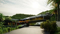
Our 3D Architectural Rendering service transforms your architectural concepts into vivid, photo-realistic visuals. Ideal for architects, real estate developers, and interior designers, these renderings provide an accurate and detailed representation of your projects, helping you visualize the final outcome before construction begins. From residential buildings to commercial complexes, our renderings bring your blueprints to life, enabling effective presentation and decision-making.

Ecotectum’s Digital Twins for Immersive Marketing use high-precision 3D scanning and modeling to create accurate digital replicas of physical products. These 3D models can be used for interactive product views, augmented reality (AR) visualization, and virtual try-ons, helping businesses integrate realistic 3D content into their online platforms to improve customer experience and reduce return rates.

DOMIGRID
Preconstruction Digital Twins for Prefab & Modular Projects
Domigrid is Ecotectum’s flagship digital twin platform—built specifically for the prefab and modular real estate sector. Focused on the preconstruction phase, Domigrid transforms BIM models into cinematic, real-time simulations that help developers secure approvals, align stakeholders, and pitch projects with confidence.


